History
The need for a comprehensive and accessible system for the locations of Kentucky underground and surface mines was reinforced with the Martin County Coal Company slurry impoundment failure on October 11, 2000. Near Inez, a slurry impoundment suffered a crack, releasing 250 million gallons of slurry into an underlying coal mine and adjacent creeks. Fortunately, no lives were lost, but there were extensive environmental damages.
As the Kentucky Mine Mapping project was underway, another coal mining disaster occurred at Quecreek Mine in Pennsylvania on July 24, 2002. Again, luckily no lives were lost. These mine disasters strengthened the urgency for the commonwealth to develop a GIS (Geographic Information System) Mine Mapping System and to revise the statutes, regulations, and agency policies on how mine mapping information is shared within the commonwealth.
These and other coal mining disasters prompted the U. S. Mine Safety and Health Administration (MSHA) to establish a task force to review the availability, accuracy, and quality of mine maps. In response to a congressional mandate, the National Research Council conducted a study for determining the adequacy of mine maps in relation to coal waste impoundment location and stabilization methods, and published the results in Coal Waste Impoundments: Risks, Responses, and Alternatives .
 For more than 150
years, the coal regions of eastern and western Kentucky have undergone
widespread mining. Underground (deep) mining was the dominant mining
technique until the 1950s when the development of large-scale
excavation and transportation equipment made surface (strip) mining
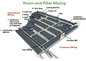
more efficient. Most of Kentucky’s underground mines used a
method called room-and-pillar mining, whereby 20 to 50 percent of the
coal is left in the mine to support the overlying rock. In instances
where the remaining coal pillars are insufficient to bear the weight of
the overlying rock, subsidence of the mine roof will occur. Subsidence
may occur decades or centuries after an underground mine is abandoned.
All undermined areas are at risk of subsidence, but it is not possible
to predict when, if ever, subsidence will occur at a given locality.
For more than 150
years, the coal regions of eastern and western Kentucky have undergone
widespread mining. Underground (deep) mining was the dominant mining
technique until the 1950s when the development of large-scale
excavation and transportation equipment made surface (strip) mining
more efficient. Most of Kentucky’s underground mines used a
method called room-and-pillar mining, whereby 20 to 50 percent of the
coal is left in the mine to support the overlying rock. In instances
where the remaining coal pillars are insufficient to bear the weight of
the overlying rock, subsidence of the mine roof will occur. Subsidence
may occur decades or centuries after an underground mine is abandoned.
All undermined areas are at risk of subsidence, but it is not possible
to predict when, if ever, subsidence will occur at a given locality.
 There is extensive mine mapping information available among the various
Kentucky state agencies, although the majority of the maps and data are
not in digital format. Until recently, laws and regulations have
hindered or prevented access between agencies and to the public. The
Mine Mapping team proposed legislation to make information sharing
easier. Governor Paul Patton signed into law SB165, which allows for
enhanced sharing and access to mine mapping information, and eliminates
the restriction for releasing active mine information that is in place
for the Division of Mine Safety (see Techlines, April 2003 Edition
for complete story).
There is extensive mine mapping information available among the various
Kentucky state agencies, although the majority of the maps and data are
not in digital format. Until recently, laws and regulations have
hindered or prevented access between agencies and to the public. The
Mine Mapping team proposed legislation to make information sharing
easier. Governor Paul Patton signed into law SB165, which allows for
enhanced sharing and access to mine mapping information, and eliminates
the restriction for releasing active mine information that is in place
for the Division of Mine Safety (see Techlines, April 2003 Edition
for complete story).
History of the Mine Mapping Information System
The Kentucky Geological Survey, in cooperation with the U.S. Office of Surface Mining and the Kentucky Department for Surface Mining Reclamation and Enforcement initiated a meeting on September 20, 2001. The meeting was held to discuss the administrative, legal, technical, and financial aspects for developing a comprehensive mine mapping system. Subsequent to this meeting, there was a follow-up meeting on January 7, 2002 to discuss an ideal mine mapping system. Agencies involved in the initial two meetings included: U.S. Office of Surface Mining, U.S. Army Corp of Engineers, U.S. Bureau of Land Management, U.S. Mine Safety and Health Administration, Kentucky Department of Surface Mining Reclamation and Enforcement, Kentucky Department of Fish and Wildlife, Governor’s Office for Technology, Kentucky Transportation Cabinet, Kentucky Geological Survey, Kentucky Department of Insurance, Kentucky Revenue Cabinet, and Virginia Department of Mining.
Outcomes from this meeting included the formation of two teams--technical and legal. These teams were charged with developing feasibility strategies for the development of a mine mapping system. The Mine Mapping Information System project officially started in March 2002.
The technical team began to determine strategies for improving the sharing and accessing of mine related information for more effective risk mitigation purposes and emergency response purposes. Strategies included both short-term and long-term goals. The technical team recognized that the agencies collect some of the same data and that reducing the duplication efforts would be beneficial. Accuracy of mine data was a priority.
Initial endeavors by the legal team included reviewing the current statutes and agencies’ policies for releasing mine related information to government agencies and the public, as well as determining what should be done to improve the access and release of information. The legal team was also responsible for researching legal related questions/issues from the technical team.